
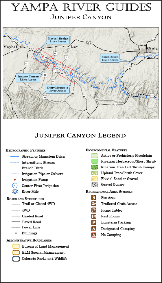
The Juniper Canyon guide covers 18.5 miles of the Yampa River, from the Duffy Mountain boat ramp (the Little Yampa Canyon takeout) to the Maybell Bridge boat ramp just east of the town of Maybell. The Juniper Canyon guide includes three maps.
After exiting the Little Yampa Canyon, the Yampa River winds slowly through the open ranchlands of the Axial Basin, a flatwater section covered by Maps 1 and 2 of the guide. The Axial Basin section is included primarily for boaters with whitewater skills who wish to extend their Little Yampa Canyon trip downstream for a final exciting run through Juniper Canyon.
After crossing the Axial Basin, the Yampa River enters Juniper Canyon. Whitewater boaters who are just interested in this short (6 mile) run will start their trip at the Juniper Canyon boat ramp. The entire run through Juniper Canyon is covered by Map 3.
Warning! The Maybell Ditch rapid in Juniper Canyon is a significant whitewater run, and should not be attempted by parties without whitewater skills and appropriate watercraft. Also be advised that portaging around the new diversion and headgate can be a difficult, time-consuming challenge. If you are not prepared to run the rapid, your best option is to take out at the Juniper Canyon boat ramp.
Current Version Date 02-22-2026
How to Print Your Guides
Print It On Legal Paper
Ideally, your Yampa River Guide should be printed on legal-size paper, using a duplex (prints to both sides) printer. Whether you can print on both sides of the paper or not, be sure to select the “Actual Size” option in the print wizard (this keeps the printer software from adding an extra margin to the printed page).
Duplexed pages will lay out like a book, with each map page on the right and its corresponding text page facing it on the left. Your pages can then be stapled, or laminated and spiral bound for a more durable guide. You might also consider printing on waterproof paper.
Printing on Letter Paper
Yampa River Guides can also be printed successfully on letter-size paper—the maps and print will just appear smaller. When printing on letter-size paper, be sure to select the “Fit” or “Fit to Page” option in the print wizard.